Basilicata · Matera
San Mauro Forte
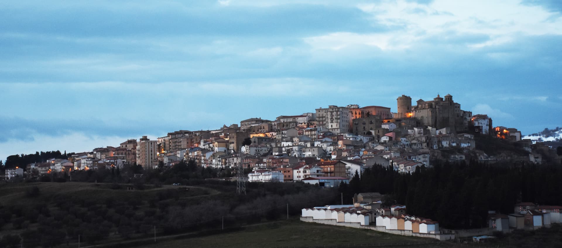
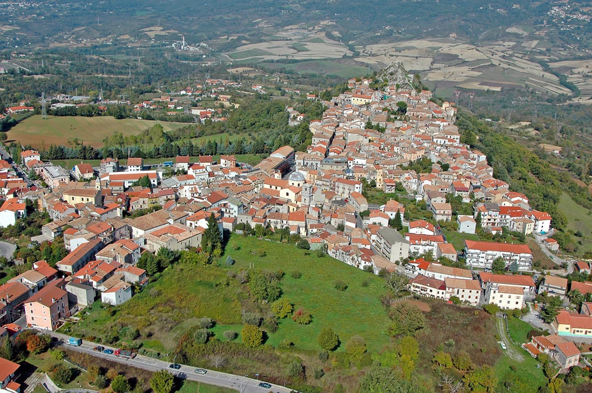
A 540-meter Lucanian hill town built around a surviving Norman tower, where the Sagra dei Campanacci on 16 January wakes the village with cowbells.
Known for
CAMPANACCI
The 16 January Sagra dei Campanacci, a transhumance and propitiatory rite where men walk the streets wrapped in belts of cowbells.
NORMAN TOWER
Cylindrical Torre Normanna in the main piazza, the surviving element of the medieval castle and the visual anchor of the borgo.
OIL
Olive groves dominate the commune territory; San Mauro Forte holds Città dell'Olio status alongside its medieval landmarks.
When to visit
Best · Apr–Oct
- J
- F
- M
- A
- M
- J
- J
- A
- S
- O
- N
- D
- Best
- Hot or crowded
- Quiet
- Mostly closed
The festa: Mauro, 23 May
Why come
San Mauro Forte sits at 540 meters in the western Matera hills, fifty-five kilometers from the Sassi and forty from Pietrapertosa. The Timponi site, with eighth-century BC remains and fourth-century BC tombs, places the area inside the Lucanian prehistoric network. The current settlement was founded around 1060 in the Norman period and takes its name from a Benedictine monastery dedicated to Saint Maurus.
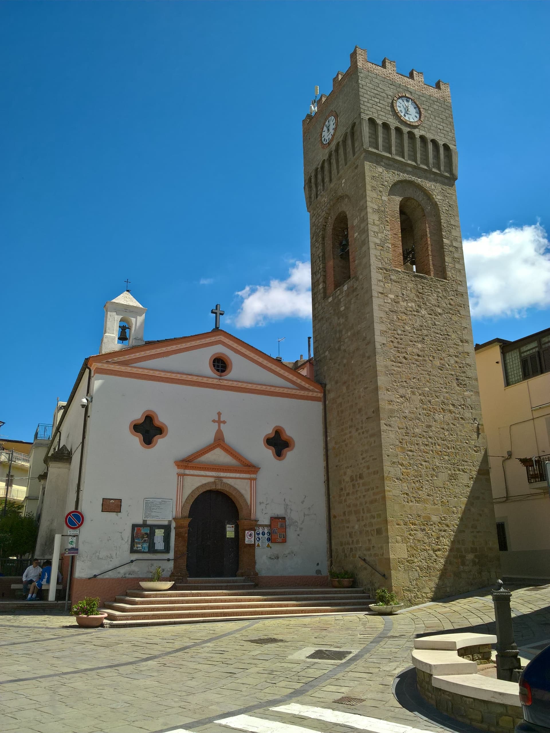
The Torre Normanna, the cylindrical defensive tower in the main piazza, is the surviving element of the Norman-Swabian castle, later rebuilt by the Angevins. The Chiesa di Santa Maria Assunta of 1553 preserves a sixteenth-century processional cross. The town's calendar is dominated by the Sagra dei Campanacci on the eve of Sant'Antonio Abate, on 16 January, when men strap belts of cowbells around their waists and walk the streets at dusk in a transhumance rite that predates the church and was kept alive by the shepherding economy. The town carries Città dell'Olio status: olive groves cover much of the commune.
The Sunday letter
We haven’t written San Mauro Forte’s letter yet.
One town every Sunday, with the photo, the food, the festa. Be there when this one comes up. Free, by Peter & Sophia from Pietrasanta.
By subscribing you agree to Substack’s Terms of Use, our Privacy Policy and our Information collection notice.

What to see
Torre Normanna
Cylindrical Norman tower in the main piazza, the surviving element of the Norman-Swabian castle, rebuilt by the Angevins.
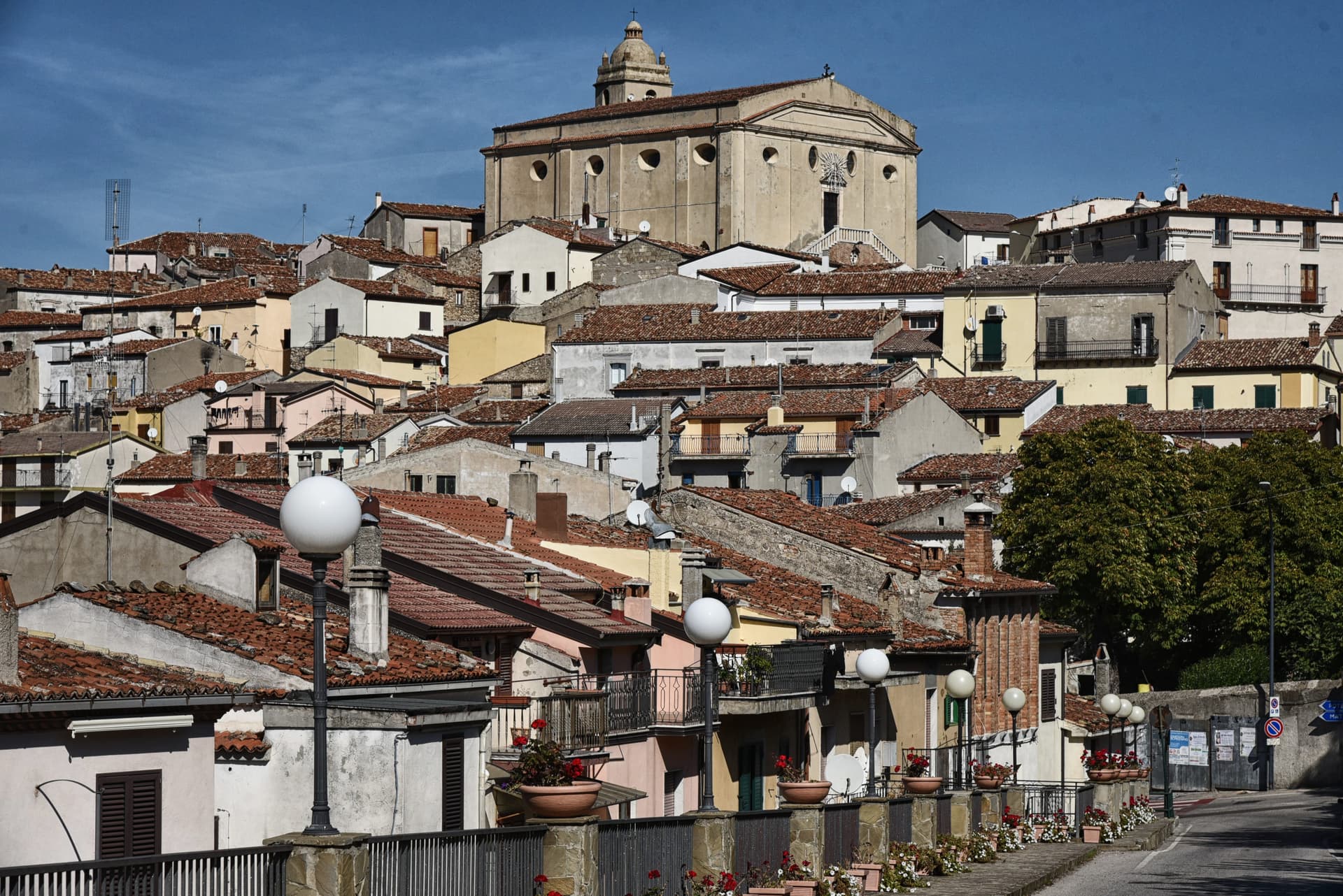
Chiesa di Santa Maria Assunta
Mother church built in 1553 inside the medieval centre, preserving a sixteenth-century astile cross and an eighteenth-century canvas.
Chiesa e Convento dell'Annunziata
Franciscan complex begun in the late fifteenth century, with the convent attached to the church of the Annunciation.
Chiesa di San Rocco
Small church dedicated to the protector against plague, part of the Franciscan-era religious building campaign.
Sito archeologico dei Timponi
Eighth-century BC settlement evidence and fourth-century BC tombs, in the commune territory outside the centre.
The slow-trip planner
Building a trip? Find where San Mauro Forte fits in a slow Italy circuit.
Answer five questions. We will shape a geographically coherent slow trip from the 1,000 Italian towns most travelers skip. Yours to save and share.
Living here
- Population 1,265
- Off the beaten pathi
- Pharmacy in town
- Nearest high school over ~30 minutes away
- Nearest airport Bari / Brindisi, 2 h 13 min drive
- Regional capital Potenza, 1 h 15 min drive
Tags & datadesignations · numbers · sources
Recognised as
The numbers
- Elevation: 540 m
- Population: 1,265
- Surface area: 87.06 km²
These figures were compiled from public directories — ISTAT, OpenStreetMap, Wikidata — and from the official listings of the guides named on this page. Town details change; verify with official sources before you travel.
Close by
More towns near San Mauro Forte
Accettura
Province: Matera
A 770-meter village in the Gallipoli Cognato park where, each Pentecost, a Turkey oak is married to a holly tree.
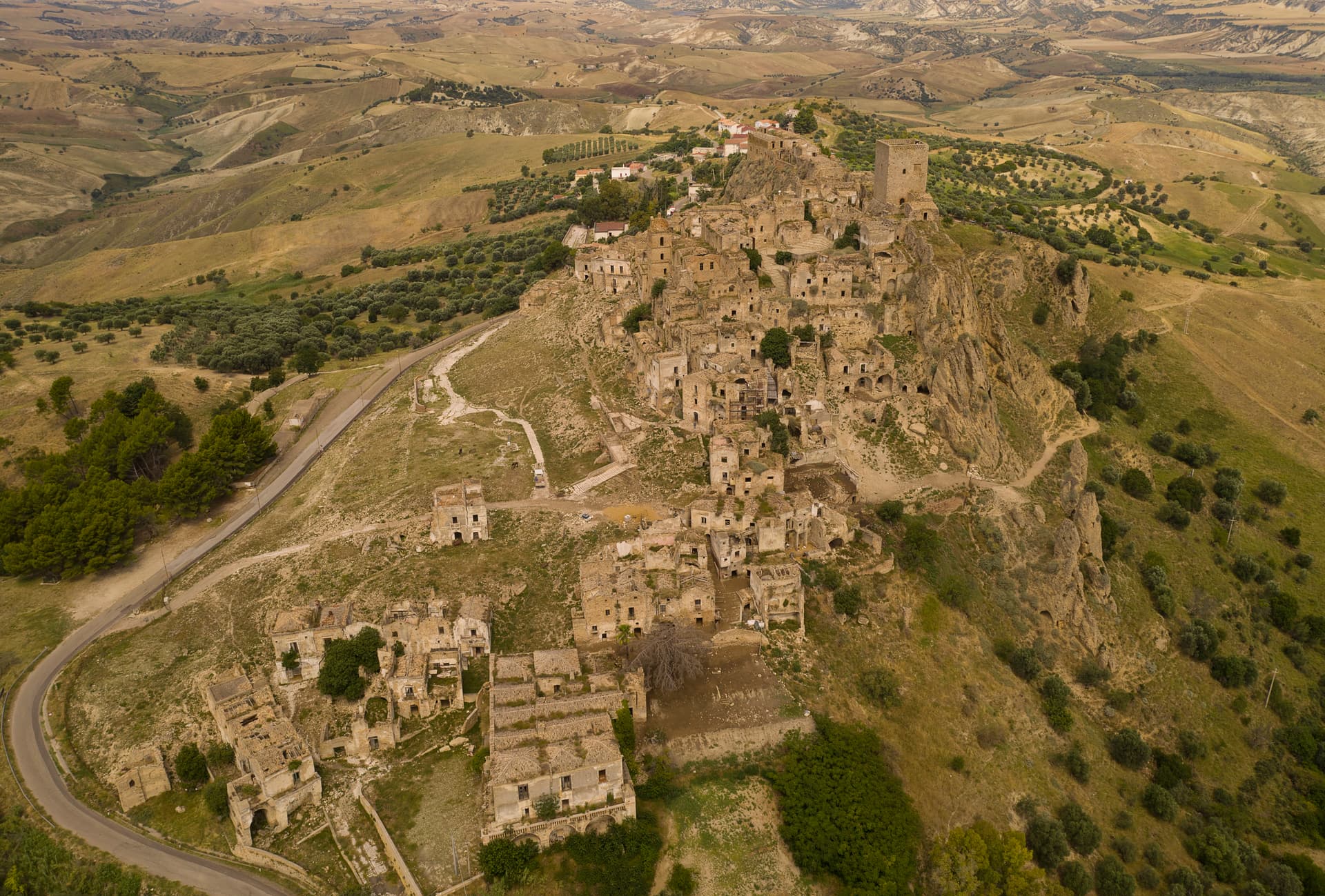
Craco
Province: Matera
A medieval ghost town on a 391-meter clay cliff, abandoned after the 1963 landslide and the 1980 Irpinia earthquake, filming location of Gibson and Bond.
Stigliano
Province: Matera
At 909 meters on the northern edge of the Lucanian calanchi, the highest commune in Matera province, Basilicata's capital under the Spanish Medina from 1556.
Grottole
Province: Matera
A hilltop borgo at 481 meters between the Bradano and Basento, where six hundred empty houses outnumber residents in the centro storico.
Pietrapertosa
Province: Potenza
Basilicata's highest commune at 1,088 meters, built into the Lucanian Dolomites with a Saracen rock-cut fortress and a 1,400-meter zipline to Castelmezzano.
💎 Borghi Autentici
More Borghi Autentici towns in Basilicata
Aliano
Province: Matera
The clay-hill village at 555 meters above the Agri valley where Carlo Levi served his 1935 exile and is buried in the cemetery.
Rotonda
Province: Potenza
The Pollino park's Lucanian gateway — a 3,171-resident borgo at 626m on the Basilicata/Calabria border, headquartered HQ for the Parco Nazionale del Pollino (Italy's largest national park), with the Fagiolo Bianco Poverello + Melanzana Rossa di Rotonda DOP slow-food products, the Borgo Autentico mark, and the Loricato pine forests immediately above town.