
Trentino-South Tyrol · Trento
Lavarone
A Cimbrian plateau at 1,172 metres above the Val d'Astico, with a karst lake, an Austro-Hungarian fort, and the woods where Freud walked.
Known for
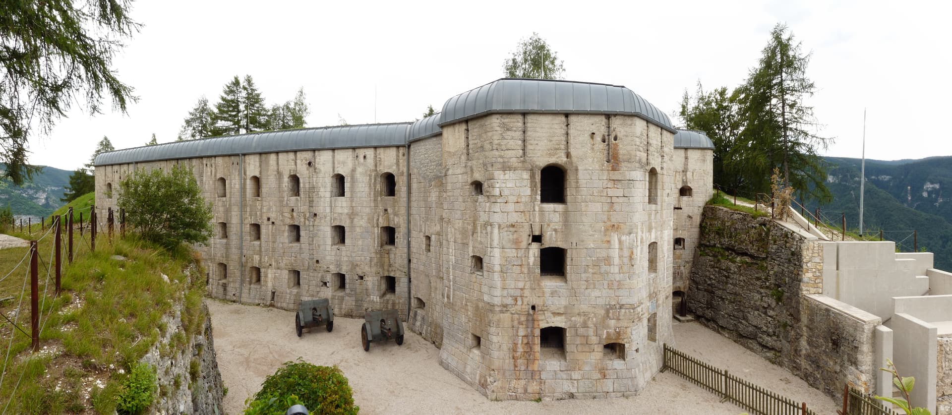
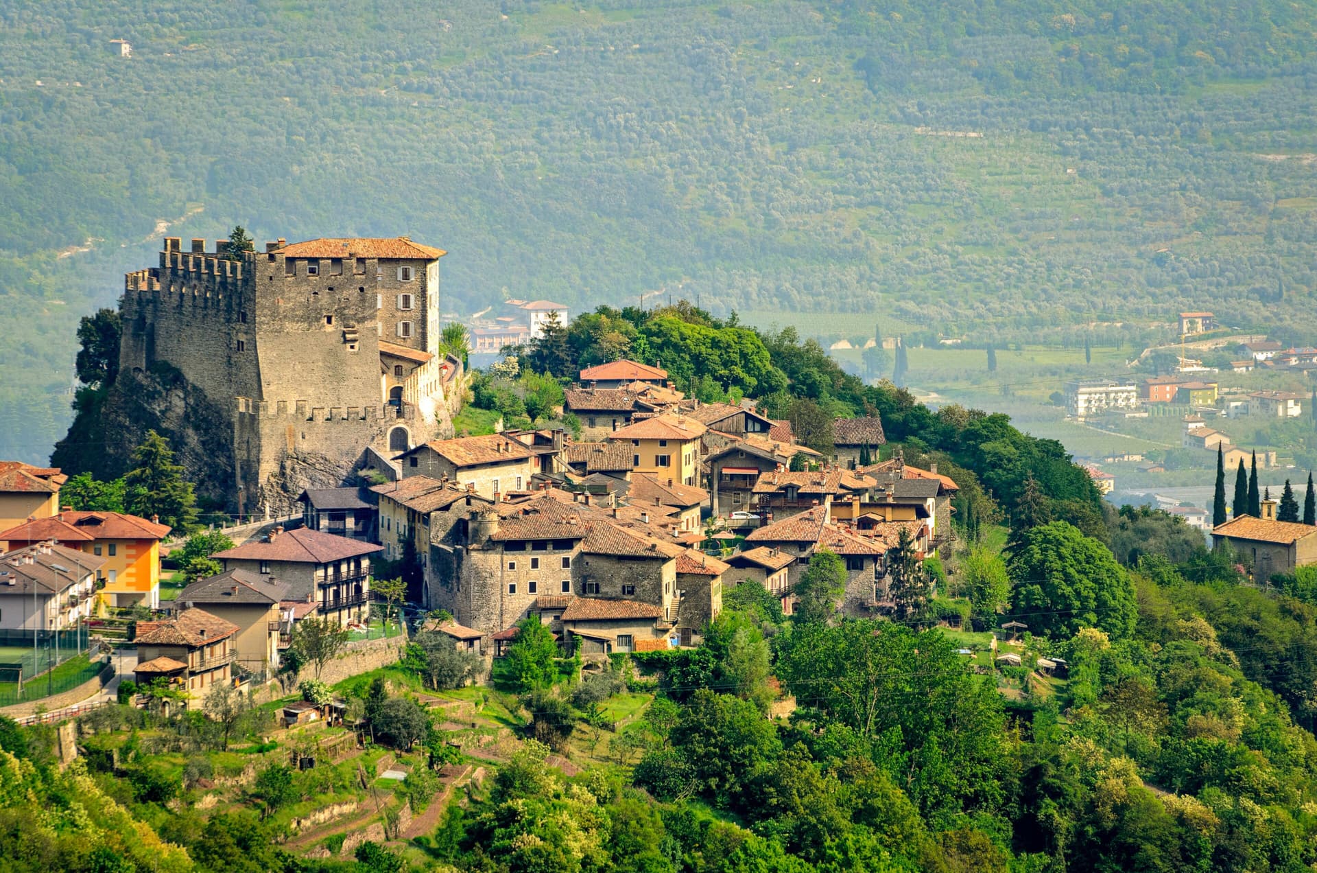
FORTE BELVEDERE
Austro-Hungarian fort built 1908-1912 on a limestone spur over the Val d'Astico, one of the best-preserved Great War fortifications in Trentino.
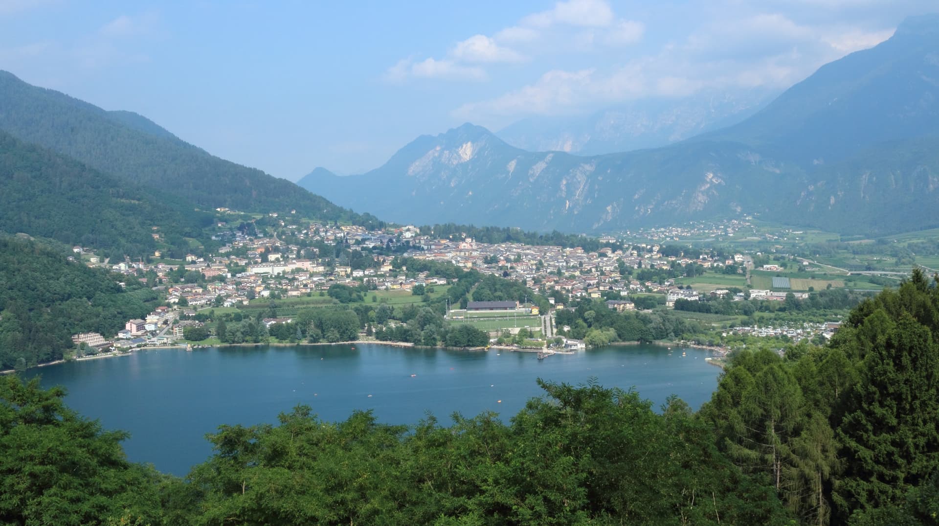
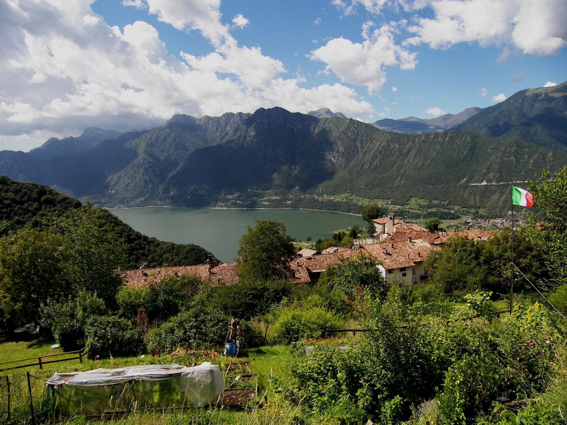
LAGO DI LAVARONE
Karst lake at 1,079 metres holding a Bandiera Blu, set in conifer woods where Sigmund Freud spent three summer holidays.
CIMBRIAN PLATEAU
Settled by Bavarian colonists from the tenth century, part of the Magnifica Comunità degli Altipiani Cimbri with neighbouring Luserna.
When to visit
Best · Jun–Sep, Dec–Mar
- J
- F
- M
- A
- M
- J
- J
- A
- S
- O
- N
- D
- Best
- Hot or crowded
- Quiet
- Mostly closed
The festa: Floriano di Lorch, 4 May
Why come
Lavarone sits at 1,172 metres on a forested plateau between the Folgaria highlands and the Cimbrian island of Luserna, the southern edge of the Alpe Cimbra ski circuit. The territory is a scatter of twenty hamlets across pasture and conifer woods, settled by Bavarian-Cimbrian colonists between the tenth and thirteenth centuries. Lake Lavarone, a karst lake at 1,079 metres formed in a slowly filled sinkhole, sits at the centre of the plateau and holds a Bandiera Blu for water quality.
Sigmund Freud spent three summer holidays here in the early twentieth century, walking the shore and the conifer woods above the lake. South of the village, the Forte Belvedere Gschwent stands on a limestone spur over the Val d'Astico, an Austro-Hungarian fortress built between 1908 and 1912 that marked the imperial border with the Kingdom of Italy and now houses a Great War museum. In winter the Alpe Cimbra lifts open from the plateau hamlets above 1,000 metres.
The Sunday letter
We haven’t written Lavarone’s letter yet.
One town every Sunday, with the photo, the food, the festa. Be there when this one comes up. Free, by Peter & Sophia from Pietrasanta.
By subscribing you agree to Substack’s Terms of Use, our Privacy Policy and our Information collection notice.

What to see
Forte Belvedere Gschwent
Austro-Hungarian fortress built 1908-1912 on a limestone spur at 1,177 metres over the Val d'Astico, with armoured cupolas and a Great War museum.
Lago di Lavarone
Karst lake at 1,079 metres, formed by the filling of a sinkhole, awarded the Bandiera Blu for water quality and ringed by a conifer-shaded walking path.
Altopiano di Lavarone
Forested plateau between the Folgaria highlands and Luserna, a scatter of twenty hamlets across pasture and woods at 1,000 to 1,200 metres.
Alpe Cimbra ski area
Folgaria-Lavarone-Lusérn ski circuit with slopes from the plateau hamlets above 1,000 metres, part of the Skirama Dolomiti card.
Freud's path
Lakeside trail marking the three summer holidays Sigmund Freud spent at Lavarone in the early twentieth century, with information panels along the route.
The slow-trip planner
Building a trip? Find where Lavarone fits in a slow Italy circuit.
Answer five questions. We will shape a geographically coherent slow trip from the 1,000 Italian towns most travelers skip. Yours to save and share.
Living here
- Population 1,186
- Off the beaten pathi
- Pharmacy in town
- High school within a 30-minute drive
- Nearest airport Verona, 1 h 43 min drive
- Regional capital Trento, 43 min drive
Tags & datadesignations · numbers · sources
Recognised as
The numbers
- Elevation: 1172 m
- Population: 1,186
- Surface area: 26.32 km²
These figures were compiled from public directories — ISTAT, OpenStreetMap, Wikidata — and from the official listings of the guides named on this page. Town details change; verify with official sources before you travel.
Close by
More towns near Lavarone

Luserna
Province: Trento
A Cimbrian island at 1,333 metres on the Alpe Cimbra plateau, the last village in Italy where the medieval Bavarian dialect is still spoken at home.
Levico Terme
Province: Trento
A Habsburg spa town in the Valsugana at 520 metres, with arsenic-iron thermal waters, an English park and a Blue Flag lake at the edge of the centre.
Trento
Province: Trento
The Alpine capital on the Adige at 194 metres, where the Council that reshaped the Catholic Church met in a castle still standing above the city.
Borgo Valsugana
Province: Trento
The valley town built on both banks of the Brenta in lower Valsugana, with Castel Telvana above and Arte Sella in the side valley.
Rovereto
Province: Trento
The Vallagarina city at 204 metres where a Venetian-Austrian castle holds the Italian war museum and a Mario Botta dome holds Italy's largest contemporary art collection.
🟦 Bandiera Blu
More Bandiera Blu towns in Trentino-Alto Adige/Südtirol
Baselga di Pinè
Province: Trento
The main town of the Piné plateau at 964 metres, with a Blue Flag lake, Italy's outdoor speed skating oval and a baroque Marian sanctuary.
Bondone
Province: Trento
A two-village commune above Lake Idro at the Lombard border, with a Lodron castle on the cliff and a Bandiera Blu shoreline below.
Tenno
Province: Trento
A hillside commune at 428 metres above Lake Garda, with a medieval stone hamlet, a turquoise lake, and the northernmost olive groves in Europe.