
Emilia-Romagna · Ravenna
Cervia
The Adriatic salt town with 827 hectares of working saline, planned in 1697 around a grid of salt workers' houses.
Known for
SWEET SALT
Cervia's sale dolce, lower in bitter chlorides than other sea salts, harvested from 827 hectares of saline still in operation.
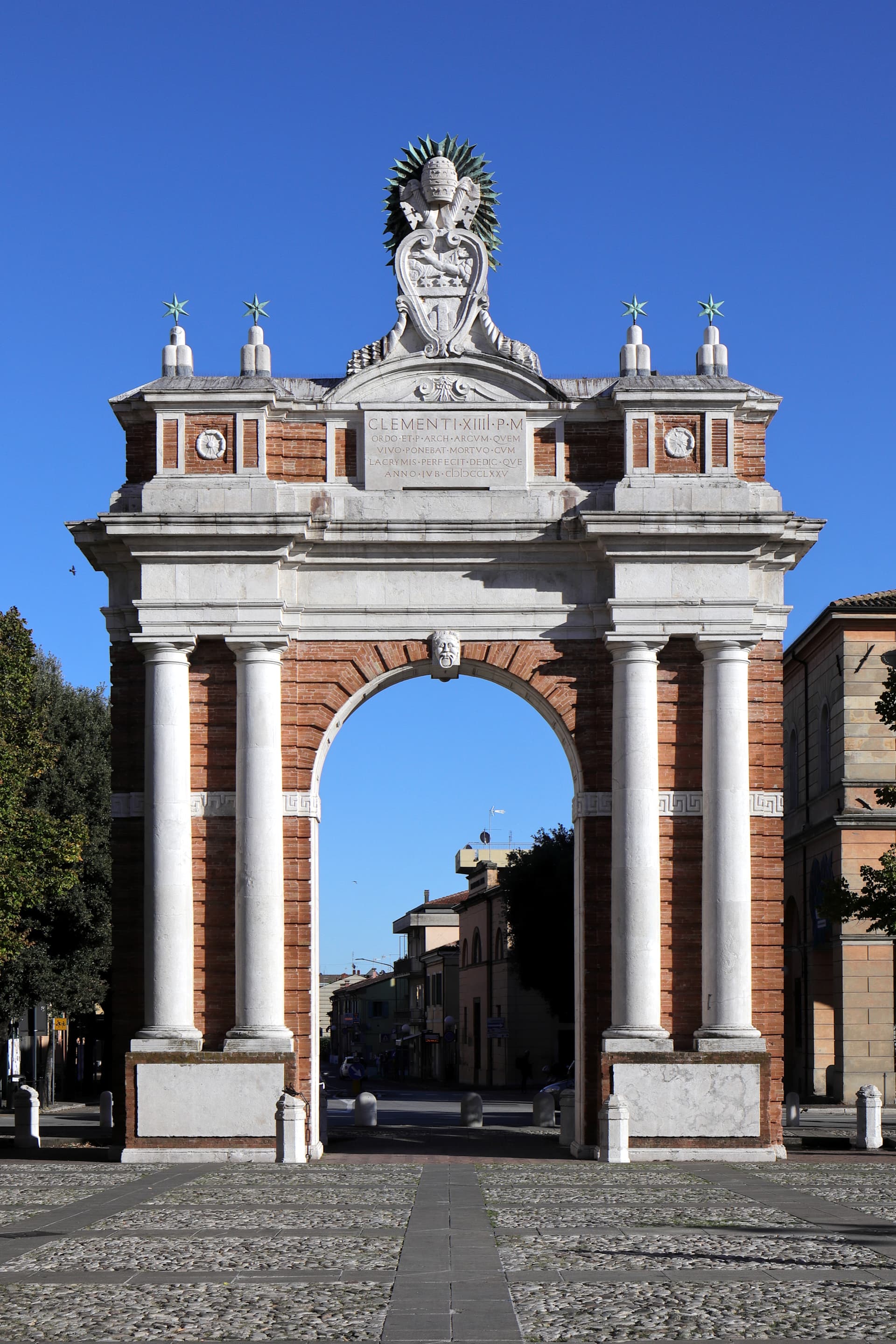
PLANNED 1697 TOWN
Built from scratch in a square grid by order of Pope Innocent XII, with identical houses for salt workers around a central piazza.
MILANO MARITTIMA
Garden-city seaside resort planned in 1912 inside the Cervia pine forest, now the northern half of the municipality.
When to visit
Best · May–Sep
- J
- F
- M
- A
- M
- J
- J
- A
- S
- O
- N
- D
- Best
- Hot or crowded
- Quiet
- Mostly closed
The festa: San Paterniano, 13 November
Why come
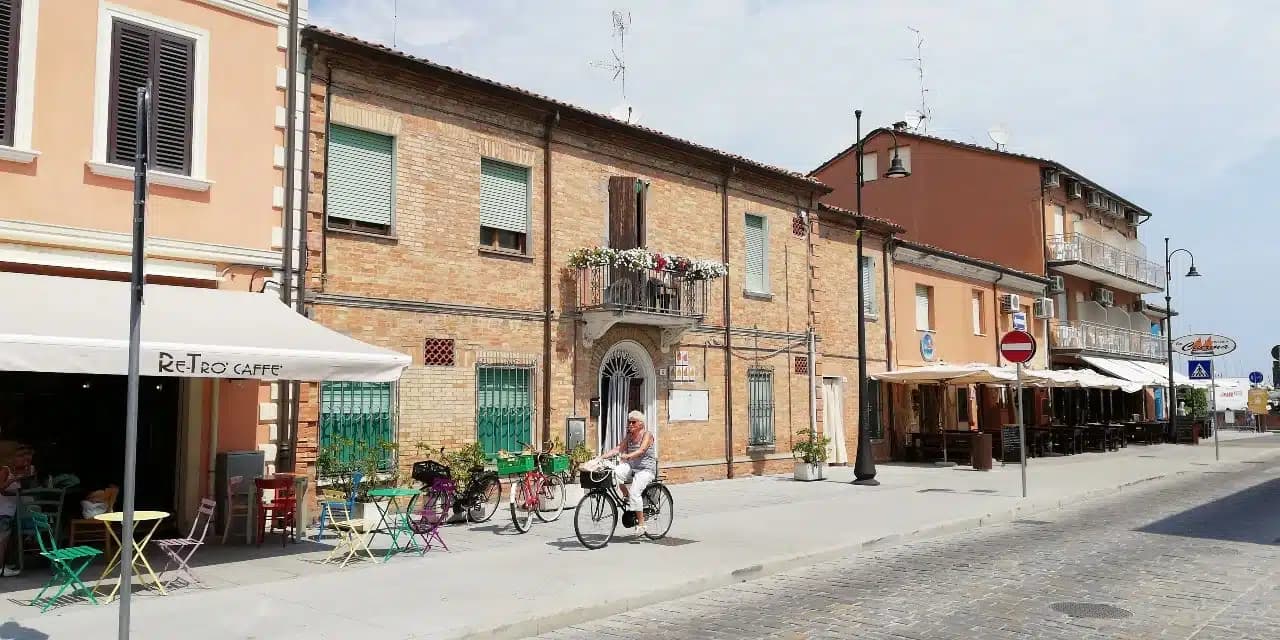
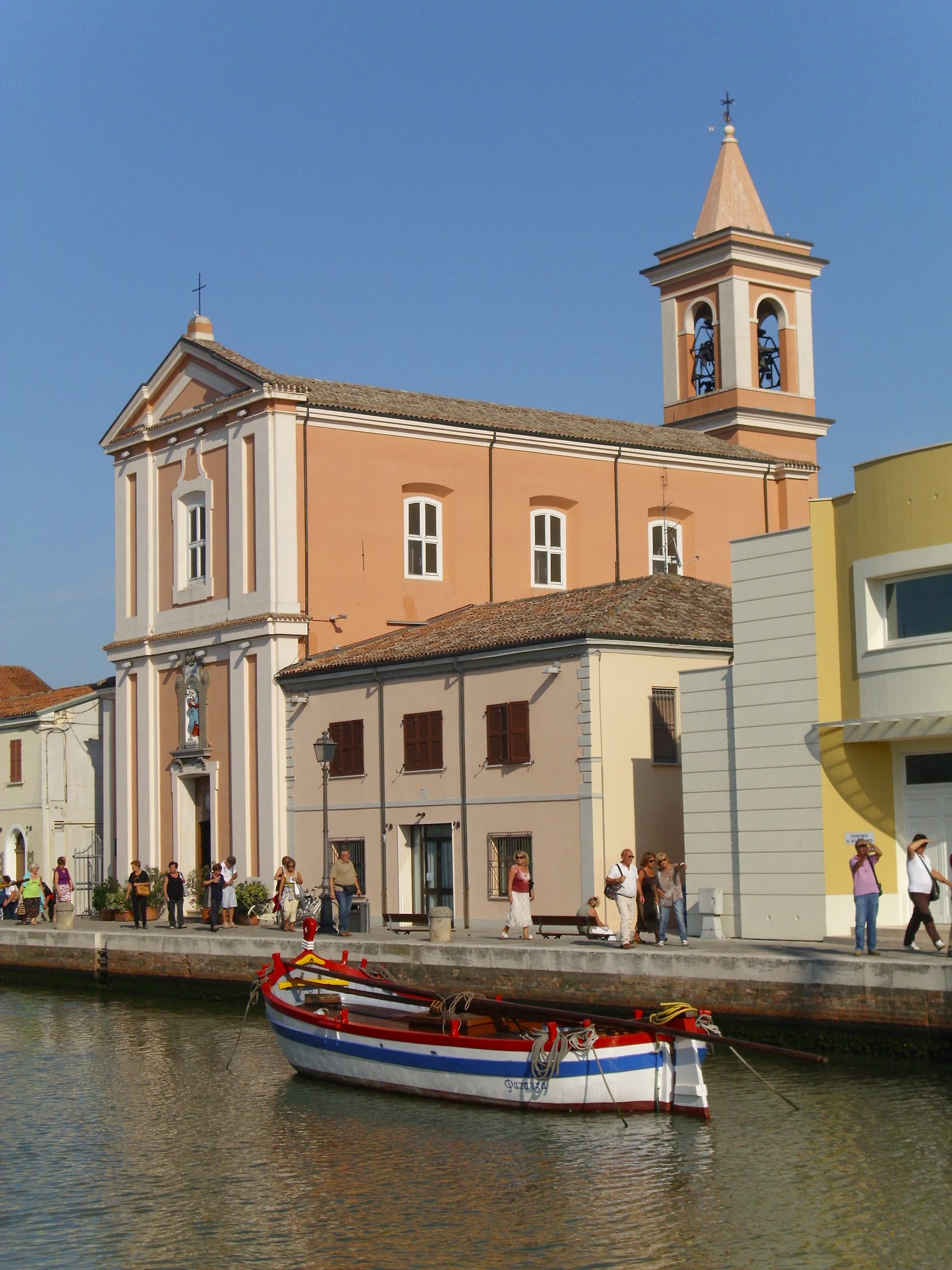
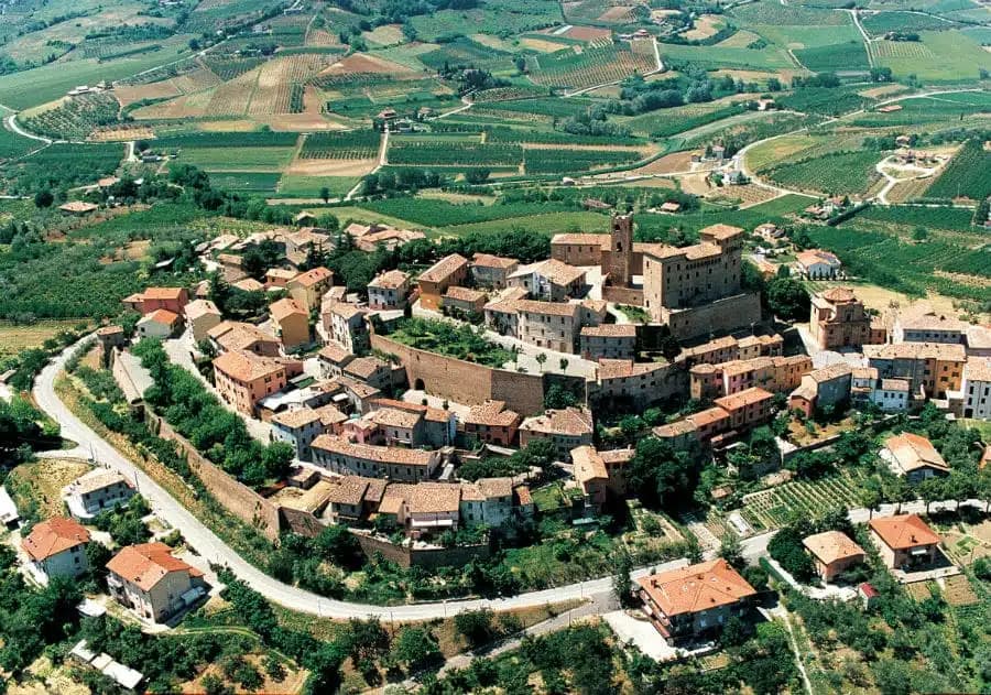
Cervia sits at sea level on the Adriatic, twenty kilometers south of Ravenna, between the pine forest of Milano Marittima and the salt pans that have given the town its identity since Roman times. The original settlement, Ficocle, stood inside the saline; in 1697 Pope Innocent XII ordered the town moved closer to the sea and rebuilt as a regular grid around a central square, the Quadrilatero, with rows of identical houses for salt workers. The Saline di Cervia still cover 827 hectares, the northernmost working salt pan in Italy, harvested by traditional methods at the Camillone basin and industrially across the rest.
The Torre San Michele, built in 1691 to guard the salt warehouses, anchors the canal port. The MUSA salt museum, set inside the Magazzino del Sale Torre, gathers two thousand years of salt-working tools and documents. Cervia carries Bandiera Blu for its nine-kilometer beach and feeds Milano Marittima, the planned 1912 garden-city resort on its northern flank.
The Sunday letter
We haven’t written Cervia’s letter yet.
One town every Sunday, with the photo, the food, the festa. Be there when this one comes up. Free, by Peter & Sophia from Pietrasanta.
By subscribing you agree to Substack’s Terms of Use, our Privacy Policy and our Information collection notice.

What to see
Saline di Cervia
Working salt pans covering 827 hectares, the northernmost in Italy, with the Camillone basin still harvested by hand using nineteenth-century methods.
Torre San Michele
Defensive tower built in 1691 to protect the salt warehouses and control the canal port, on the north side of the harbor.
MUSA - Museo del Sale
Salt museum inside the Magazzino del Sale Torre, with tools, documents and photographs gathered from former salt workers.
Quadrilatero
Grid of identical salt workers' houses built from 1697 after Pope Innocent XII ordered Cervia moved from the saline closer to the sea.
Pineta di Milano Marittima
Coastal pine forest planted in 1882, shaping the northern half of the municipality and the 1912 garden-city plan of Milano Marittima.
The slow-trip planner
Building a trip? Find where Cervia fits in a slow Italy circuit.
Answer five questions. We will shape a geographically coherent slow trip from the 1,000 Italian towns most travelers skip. Yours to save and share.
We recommend
Where to eat and stay
Not our picks, but places the guides put their name to — a Michelin star, a Gambero Rosso fork, a Slow Food snail, a Michelin Key for the hotels. Worth a table, a counter, or a night when you pass through.
Le GhiaineRistorante
Le Ghiaine has one Gambero Rosso fork (76/100) to its name.
Locanda dei SalinariRistorante
Locanda dei Salinari carries a spot in the Michelin Guide.
MicroBistrot
Micro has one Gambero Rosso table to its name.
Osteria BartoliniRistorante
Osteria Bartolini carries a Michelin Bib Gourmand.
Uni RestaurantGiapponese
Two Gambero Rosso Mappamondi, at Uni Restaurant.
Hotel WaldorfHotel
A place in the Michelin hotel guide, at Hotel Waldorf.
Living here
- Population 28,983
- Commuter belti
- Pharmacy in town
- High school within a 30-minute drive
- Train station in the comune
- Nearest airport Rimini, 59 min drive
- Regional capital Bologna, 1 h 16 min drive
Thermal baths in town: Terme di Cervia.
Tags & datadesignations · numbers · sources
Recognised as
The numbers
- Elevation: 2 m
- Population: 28,983
- Surface area: 82.27 km²
These figures were compiled from public directories — ISTAT, OpenStreetMap, Wikidata — and from the official listings of the guides named on this page. Town details change; verify with official sources before you travel.
Featured on
Cervia appears on this themed pick from our Collections:
Close by
More towns near Cervia
Cesenatico
Province: Forlì-Cesena
An Adriatic fishing port whose canal was redrawn by Leonardo da Vinci in 1502, with ten historic sailboats moored as a floating museum.
Bertinoro
Province: Forlì-Cesena
A 254-meter Romagna-hill borgo above the Via Emilia, with a twelve-ring hospitality column from 1300 and the slopes that grow Albana DOCG.
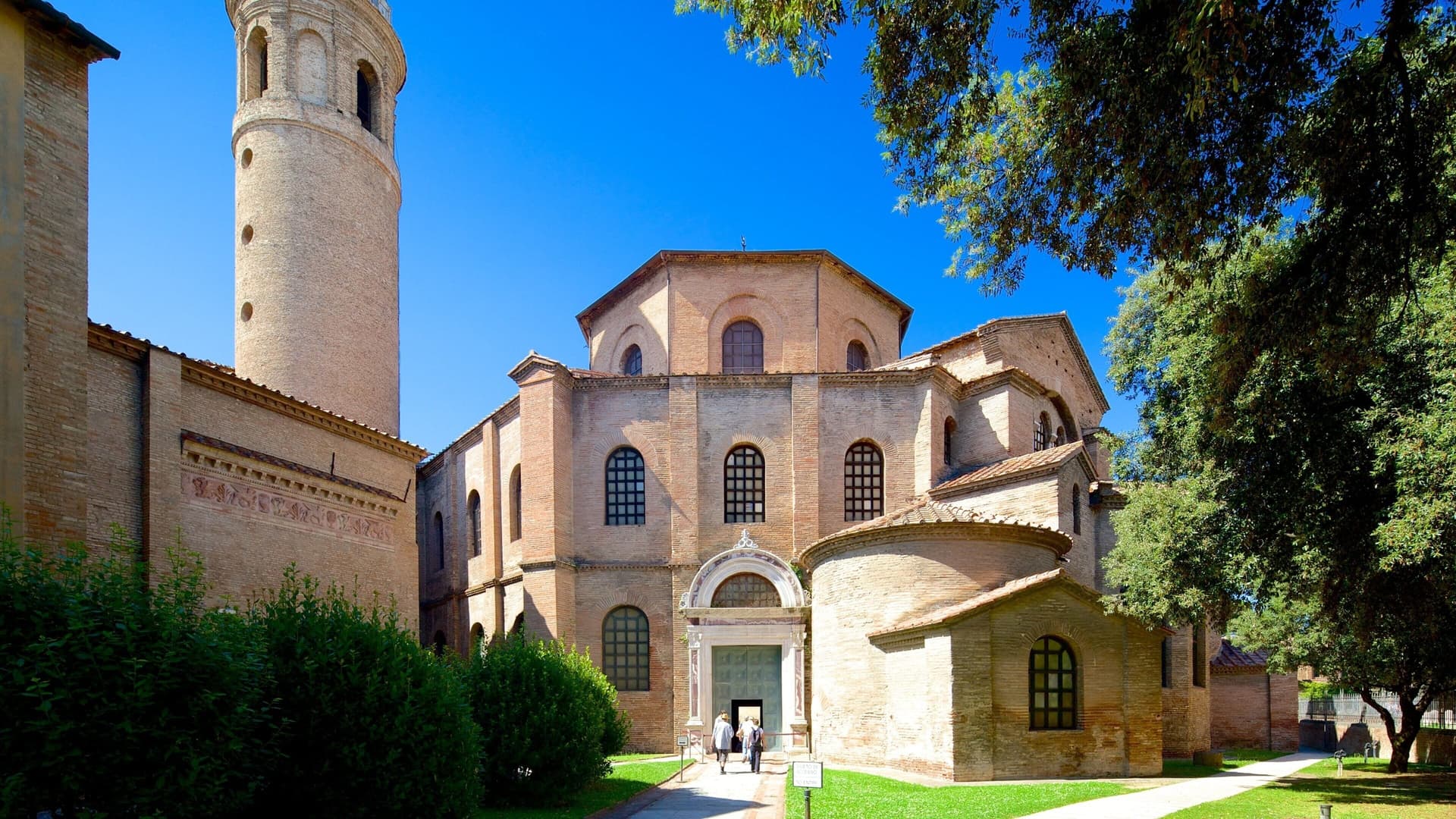
Ravenna
Province: Ravenna
A 4-meter coastal capital of three successive empires, with eight UNESCO mosaic monuments from the fifth and sixth centuries.
Santarcangelo di Romagna
Province: Rimini
A Via Emilia hill town on the Marecchia plain, with over 150 tufa caves under the centro and a Malatesta fortress on its summit.
Longiano
Province: Forlì-Cesena
A 179-meter Malatesta borgo on the hills between Cesena and Rimini, holding the Tito Balestra collection inside the family castle.
🟦 Bandiera Blu
