
Umbria · Perugia
Monte Santa Maria Tiberina
An imperial-fief borgo at 688 meters above the Upper Tiber valley, held by the Bourbon del Monte marquises from 1250 to 1815.
Known for
IMPERIAL FIEF
Bourbon del Monte marquisate held the territory as an imperial fief from 1250 to 1815, six centuries of independence from Florence and Rome.
PALAZZO BOURBON
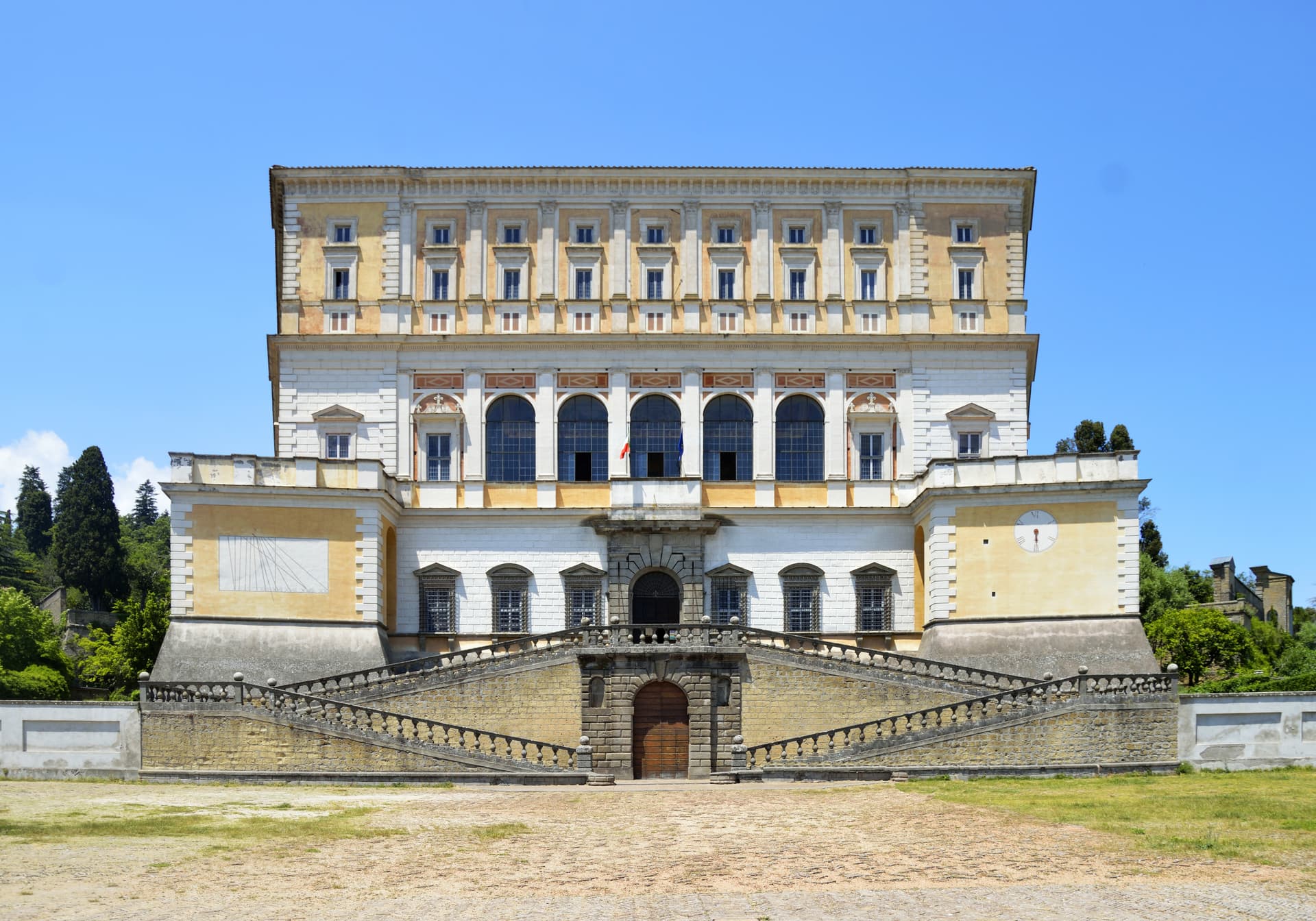
Marquis palace begun in 1564 by Bartolomeo, completed by Gianbattista in 1614, now the town's museum.
CASTAGNO
Chestnut woods on the surrounding slopes, source of Città del Castagno status and the late-October harvest.
When to visit
Best · Apr–Oct
- J
- F
- M
- A
- M
- J
- J
- A
- S
- O
- N
- D
- Best
- Hot or crowded
- Quiet
- Mostly closed
The festa: Assunzione di Maria, 15 August
Why come
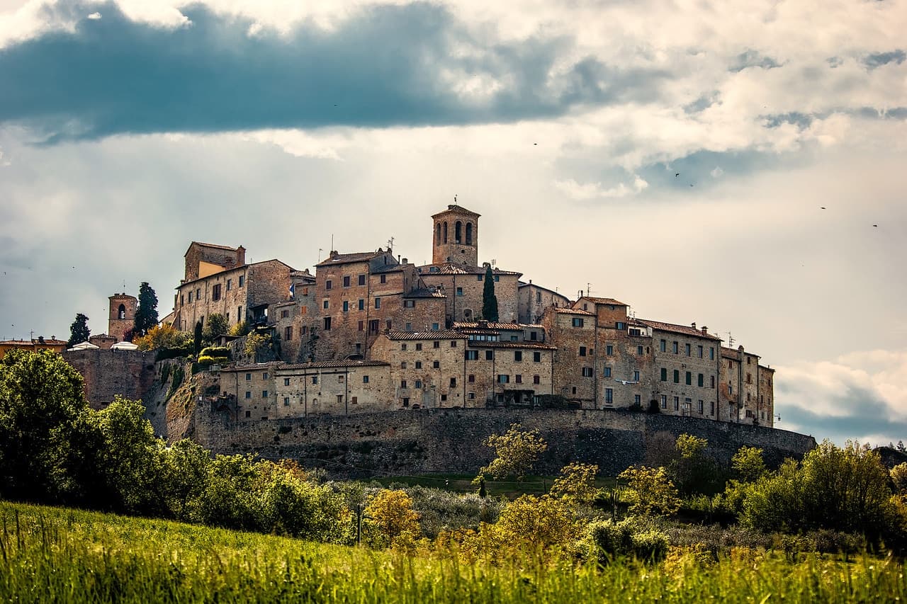
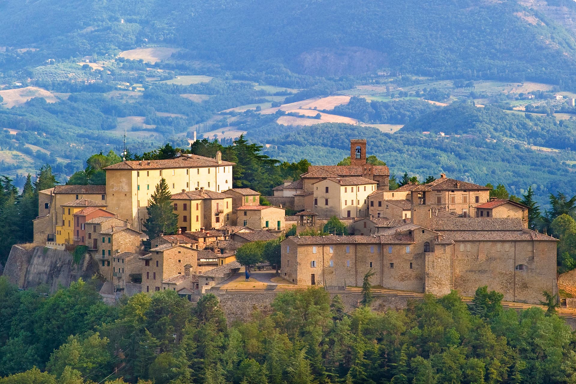
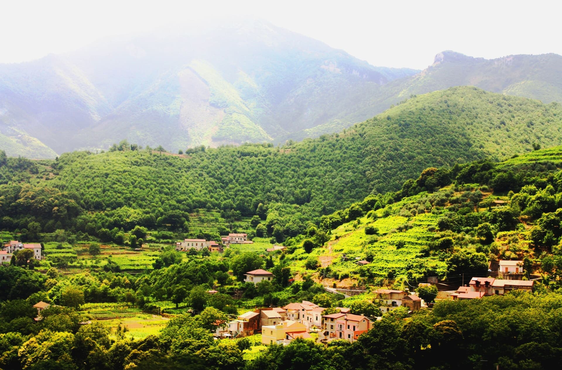
Monte Santa Maria Tiberina stands at 688 meters on the summit of the mountain that gives it its name, on the Umbria-Tuscany border above the Upper Tiber valley, forty kilometers north of Perugia. From the eleventh century the territory was a fief of the Marquis Bourbon del Monte, descendants of the Frankish Marquis del Colle who conquered much of the Upper Tiber. The Bourbon del Monte marquisate became an imperial fief in 1250 and stayed one until 1815, six and a half centuries of de facto independence from both Florence and Rome, the longest-running noble enclave in central Italy.
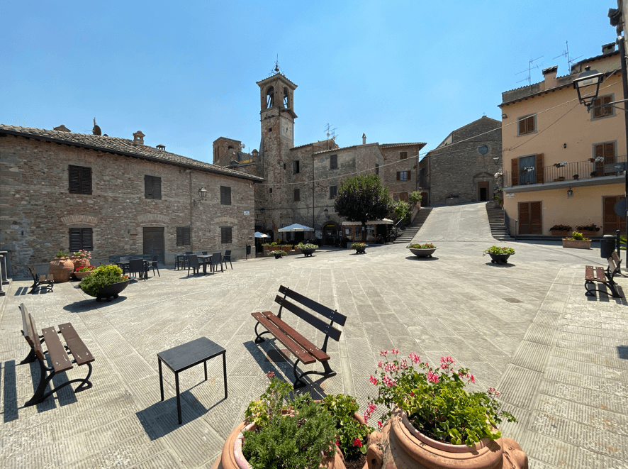
The Palazzo Bourbon del Monte in Piazza Castello, begun in 1564 by Bartolomeo and continued by his son Gianbattista, holds the family seat and now the municipal museum. The medieval walls still ring the borgo. Beyond them the slopes are chestnut woods, sweet chestnuts and pasture, the basis of the town's Città del Castagno membership.
The Sunday letter
We haven’t written Monte Santa Maria Tiberina’s letter yet.
One town every Sunday, with the photo, the food, the festa. Be there when this one comes up. Free, by Peter & Sophia from Pietrasanta.
By subscribing you agree to Substack’s Terms of Use, our Privacy Policy and our Information collection notice.


What to see
Palazzo Bourbon del Monte
Marquis seat in Piazza Castello, built 1564-1614 on earlier castle structures, now Palazzo Museo of Monte Santa Maria.
Borgo murato
Medieval walls still enclose the small summit village, a compact circuit of stone houses around the Bourbon palace.
Cappella Bourbon del Monte
Family chapel erected in 1613 by Marquis Gianbattista, part of the dynastic complex inside the walls.
Belvedere sul Tevere
View from the ridge across the Upper Tiber valley toward Citerna and the Tuscan border, the ancient Etruscan corridor.
The slow-trip planner
Building a trip? Find where Monte Santa Maria Tiberina fits in a slow Italy circuit.
Answer five questions. We will shape a geographically coherent slow trip from the 1,000 Italian towns most travelers skip. Yours to save and share.
Living here
- Population 1,085
- Off the beaten pathi
- Pharmacy in town
- Nearest high school over ~30 minutes away
- Nearest airport Ancona / Pescara, 2 h 35 min drive
- Regional capital Perugia, 1 h 16 min drive
Tags & datadesignations · numbers · sources
Recognised as
The numbers
- Elevation: 688 m
- Population: 1,085
- Surface area: 72.53 km²
These figures were compiled from public directories — ISTAT, OpenStreetMap, Wikidata — and from the official listings of the guides named on this page. Town details change; verify with official sources before you travel.
Close by
More towns near Monte Santa Maria Tiberina
Citerna
Province: Perugia
A medieval borgo at 480 meters above the upper Tiber valley, holding the only sculpture by Donatello in Umbria.

Città di Castello
Province: Perugia
The upper Tiber valley's Renaissance + 20th-c art capital — 38,000-resident walled town in the Alta Valtiberina where Raphael painted his first independent commissions, where Alberto Burri (1915-95) founded the Fondazione that now occupies the 14th-c Ex Seccatoi del Tabacco + the Palazzo Albizzini, and where the white truffle season + the Mostra del Tartufo in November are the year's headline food event.
Anghiari
Province: Arezzo
A walled medieval town at 430 meters over the upper Tiber valley, where Florence beat Milan in 1440 and Leonardo started the fresco he never finished.

Arezzo
Province: Arezzo
Tuscany's other set-piece — a 96,000-resident Etruscan-Roman-medieval hilltop city 80 km southeast of Florence, with Piero della Francesca's Leggenda della Vera Croce fresco cycle in San Francesco (1452–66), the sloped Piazza Grande set used by Roberto Benigni in Life is Beautiful, and the Fiera Antiquaria — Italy's largest monthly antique fair, running since 1968.
Montone
Province: Perugia
A walled medieval hill town at 482 meters above the upper Tiber, birthplace of the condottiero Braccio Fortebracci.
🌰 Città del Castagno
More Città del Castagno towns

Morino
Province: L'Aquila
A village at 440 meters in the Val Roveto on the Lazio border, beneath the central Apennines' second-highest waterfall at over 80 meters.
Sante Marie
Province: L'Aquila
A 950-meter Marsica village and the trailhead of the Cammino dei Briganti, the seven-day brigand trail through the Cartore band's territory.
Tramonti
Province: Salerno
The inland side of the Amalfi Coast, thirteen hamlets on the Lattari slopes producing the Costa d'Amalfi Tramonti DOC and an exported pizza dough.
Caprarola
Province: Viterbo
A Cimini hill town above Lago di Vico, dominated by the pentagonal Villa Farnese that Vignola built for the Farnese cardinals between 1559 and 1573.

Chiusa di Pesio
Province: Cuneo
The valley mouth town at 575 meters where the Pesio leaves the Ligurian Alps, founded around a Carthusian monastery donated in 1173.