
Piedmont · Cuneo
Ormea
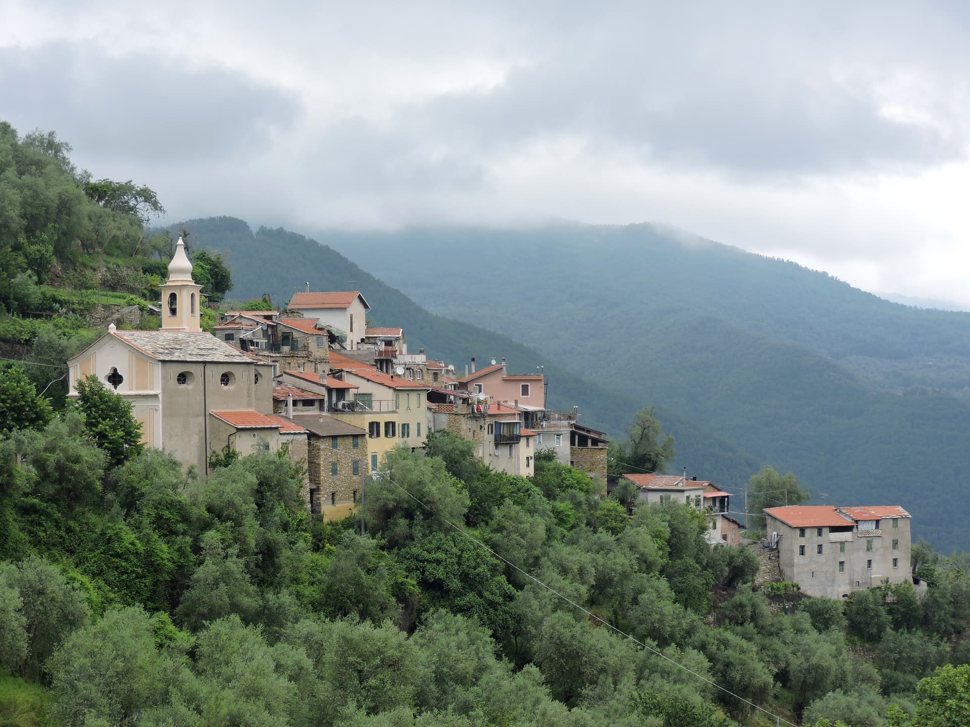
A heart-shaped Ligurian-Alps borgo at 736 meters in the upper Tanaro valley, the southernmost town in Piemonte before the Imperia ridge.
Known for
CHESTNUTS
Città del Castagno designation for the chestnut woods of the upper Tanaro, harvested and dried in traditional tecci through October.
PIZZO D'ORMEA
2,476-metre peak of the Ligurian Alps, the southern wall of the Tanaro valley, with sea views toward Albenga on clear days.
FERRERO MILL
Eighteenth-century textile factory built by Marquis Carlo Vincenzo Ferrero d'Ormea to compete with English production, destroyed under Napoleon.
When to visit
Best · May–Oct
- J
- F
- M
- A
- M
- J
- J
- A
- S
- O
- N
- D
- Best
- Hot or crowded
- Quiet
- Mostly closed
The festa: Martino di Tours, 11 November
Why come
Ormea sits at 736 meters in the upper Tanaro valley, at the confluence of the Armella stream and the river, with the Pizzo d'Ormea rising to 2,476 meters above the rooftops. The historic centre has a recognisable heart-shaped perimeter, set against the Ligurian Alps that separate Cuneo from Imperia and Albenga; on clear days the Riviera sea is visible. The territory belonged to the Aleramici and then the Marquises of Ceva from 967, contested through the 1200s with the Clavesana branch and the Republic of Genoa, before passing to the Savoys in 1558.
In 1722 it became a marquisate under Carlo Vincenzo Ferrero d'Ormea, who built a textile mill capable of competing with English production until the French Revolution and Napoleon's army destroyed both the factory in the main square and the medieval castle. The commune carries Borghi Autentici and Città del Castagno; the chestnut harvest runs the calendar from October.
The Sunday letter
We haven’t written Ormea’s letter yet.
One town every Sunday, with the photo, the food, the festa. Be there when this one comes up. Free, by Peter & Sophia from Pietrasanta.
By subscribing you agree to Substack’s Terms of Use, our Privacy Policy and our Information collection notice.


What to see
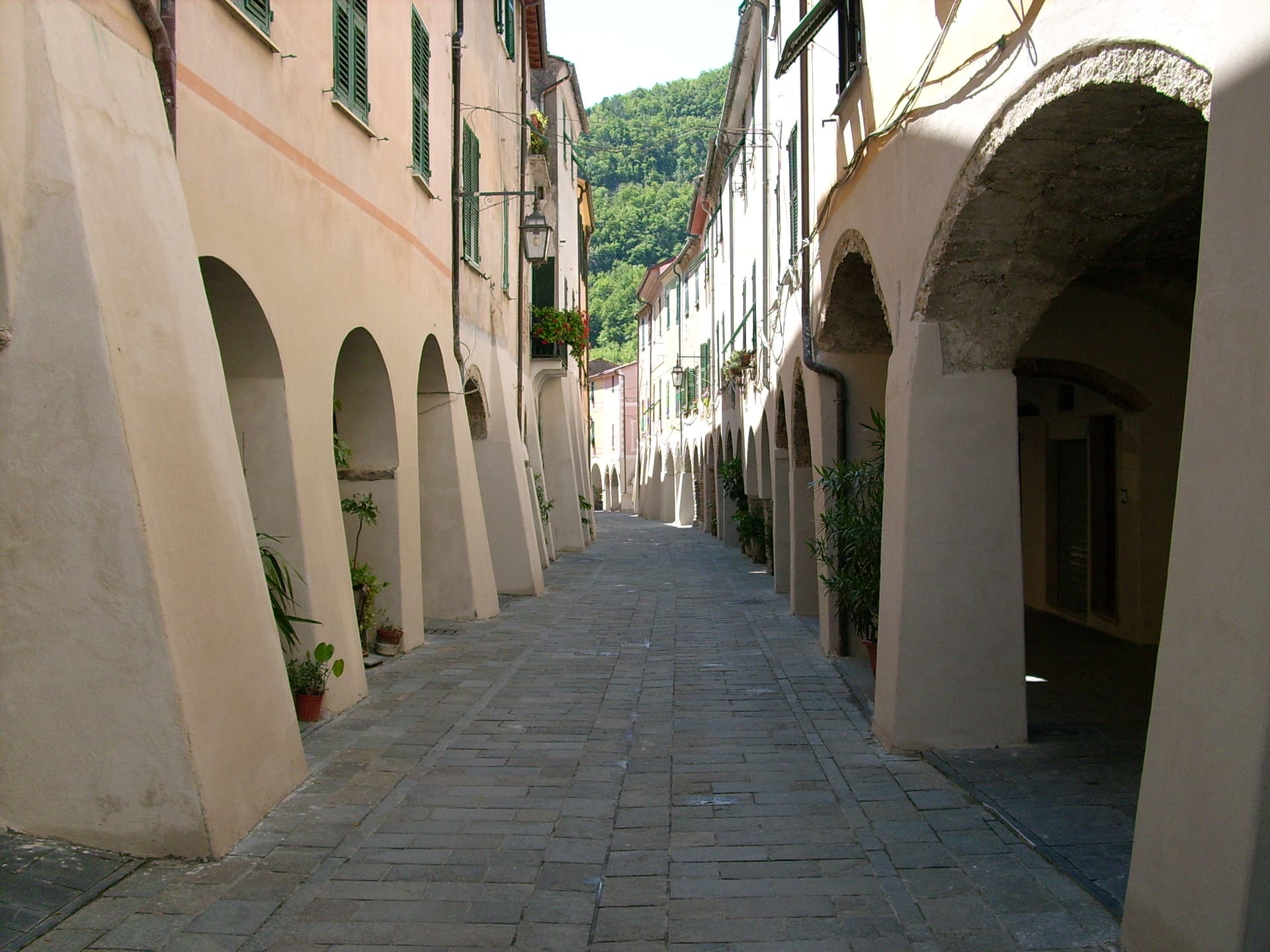
Centro storico
Heart-shaped medieval core at the confluence of the Tanaro and Armella, narrow lanes between stone houses, with views to the Pizzo d'Ormea.
Ruderi del Castello
Remains of the medieval castle held by the Marquises of Ceva and the Savoys, destroyed during Napoleon's Italian campaign at the end of the 18th century.
Pizzo d'Ormea
2,476-metre Ligurian-Alps peak above the town, the dominant summit of the upper Tanaro and a long-day hike from the centro storico.
Valle Tanaro chestnut woods
Chestnut groves that earned Ormea its Città del Castagno status, with the harvest sagra in October and traditional drying houses still in use.
The slow-trip planner
Building a trip? Find where Ormea fits in a slow Italy circuit.
Answer five questions. We will shape a geographically coherent slow trip from the 1,000 Italian towns most travelers skip. Yours to save and share.
Living here
- Population 1,478
- Off the beaten pathi
- Pharmacy in town
- High school within a 30-minute drive
- Train station in the comune
- Nearest airport Genoa, 2 h 18 min drive
- Regional capital Torino, 2 h 12 min drive
Tags & datadesignations · numbers · sources
Recognised as
The numbers
- Elevation: 736 m
- Population: 1,478
- Surface area: 124.5 km²
These figures were compiled from public directories — ISTAT, OpenStreetMap, Wikidata — and from the official listings of the guides named on this page. Town details change; verify with official sources before you travel.
Close by
More towns near Ormea

Garessio
Province: Cuneo
A four-borgo medieval town at 621 meters on the Liguria-Piemonte border, built on the salt road and the source of the Acqua San Bernardo.
Pieve di Teco
Province: Imperia
A planned market town founded in 1233 in the middle Arroscia valley, with porticoed Corso Ponzoni and the second-smallest theater in Italy.
Zuccarello
Province: Savona
A 280-person medieval borgo in the Neva valley above Albenga, founded by the Marquises of Clavesana in 1248, birthplace of Ilaria del Carretto.

Castelvecchio di Rocca Barbena
Province: Savona
A stone village of 130 residents at 420 meters in the Val Neva, built into the southern foot of Rocca Barbena at 1,142 meters.

Millesimo
Province: Savona
A fortified Del Carretto borgo at 429 meters in the upper Val Bormida, where Napoleon broke the Austro-Sardinian army in April 1796.
💎 Borghi Autentici
More Borghi Autentici towns

Archi
Province: Chieti
A 492-meter rocky spur called the Terrazza sul Sangro, fief of del Balzo, Cantelmo, Colonna and Carafa, now Città del Tartufo and Città dell'Olio.

Balsorano
Province: L'Aquila
At 359 meters in the Valle Roveto, a Piccolomini castle that became the backdrop for half of 1970s Italian horror cinema.

Barrea
Province: L'Aquila
A 1,066-meter spur above an artificial lake at the heart of the Abruzzo National Park, with a Samnite necropolis and an 11th-century di Sangro castle.

Calascio
Province: L'Aquila
At 1,200 meters under the highest castle in the Apennines, a village of 125 people that played the monk's refuge in Ladyhawke.

Campo di Giove
Province: L'Aquila
At 1,064 meters under the southwestern Maiella, the highest village in the park, named for a Roman temple to Jupiter.