
Lombardy · Sondrio
Bormio
An Alpine spa town at 1,225 meters where three high passes meet and Roman thermal water has fed the baths for two thousand years.
Known for
ROMAN THERMAL
Nine hot springs at 40 degrees feeding three thermal centres, the Bagni Vecchi used continuously since the Roman era.
STELVIO
The 2,758-meter pass road from Bormio, opened 1825, forty-eight hairpins, a regular Giro d'Italia summit and an Alpine engineering benchmark.
WORLD CUP DOWNHILL
The Stelvio piste in the Cima Bianca area hosts the men's World Cup downhill each December, one of the most technical on the circuit.
When to visit
Best · Jun–Sep, Dec–Mar
- J
- F
- M
- A
- M
- J
- J
- A
- S
- O
- N
- D
- Best
- Hot or crowded
- Quiet
- Mostly closed
The festa: Gervasio e Protasio, 19 June
Why come
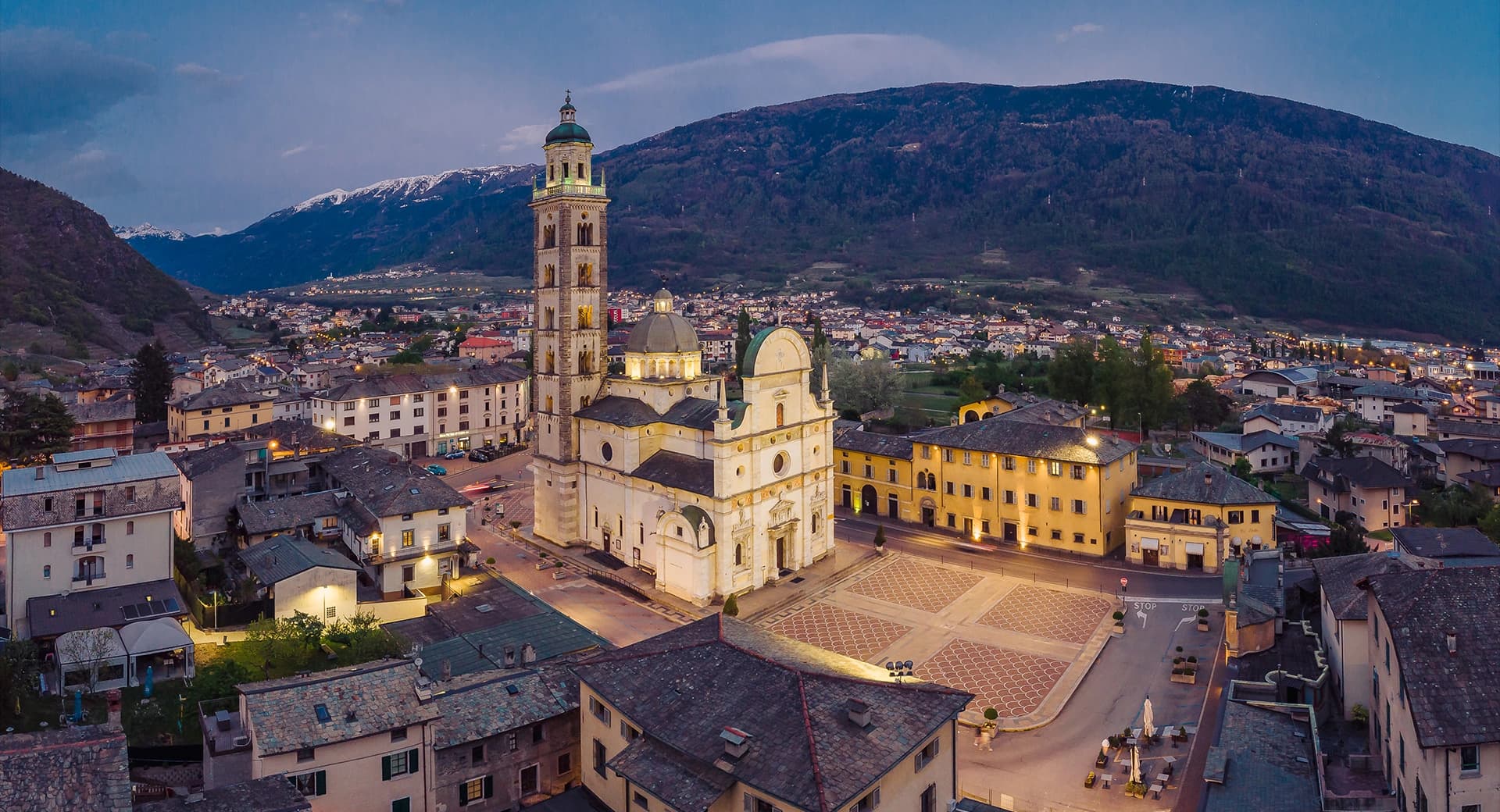
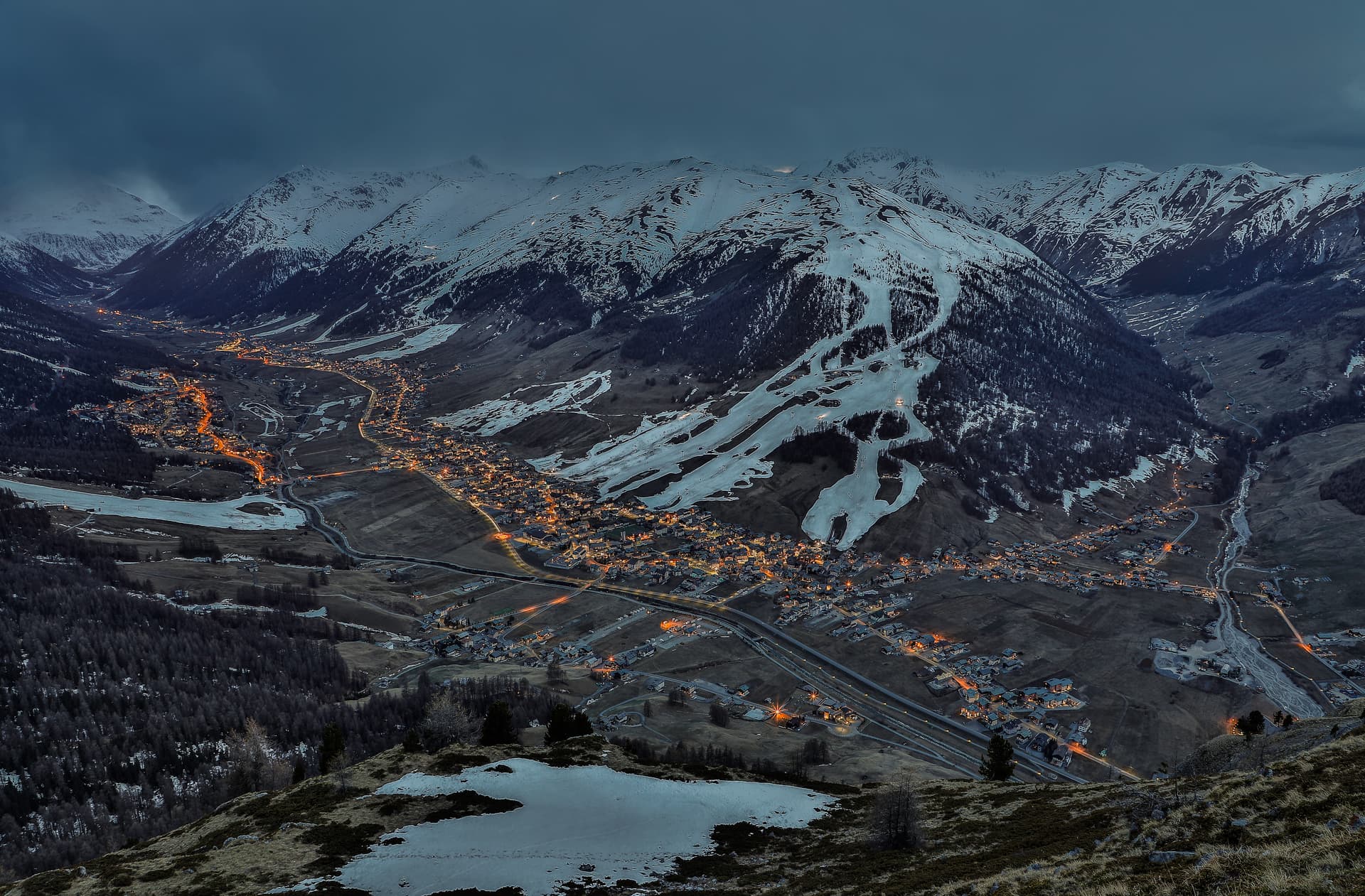
Bormio sits at 1,225 meters in upper Valtellina, the high junction where the Stelvio, Gavia, and Mortirolo passes meet inside the Stelvio National Park. The park is one of Europe's largest, 130,700 hectares ranging from 650 to 3,905 meters, with three-quarters of its surface above 2,000. The Stelvio Pass road, opened in 1825 with forty-eight hairpin bends climbing from Bormio to 2,758 meters, is a benchmark of Alpine engineering and a regular Giro d'Italia high point.
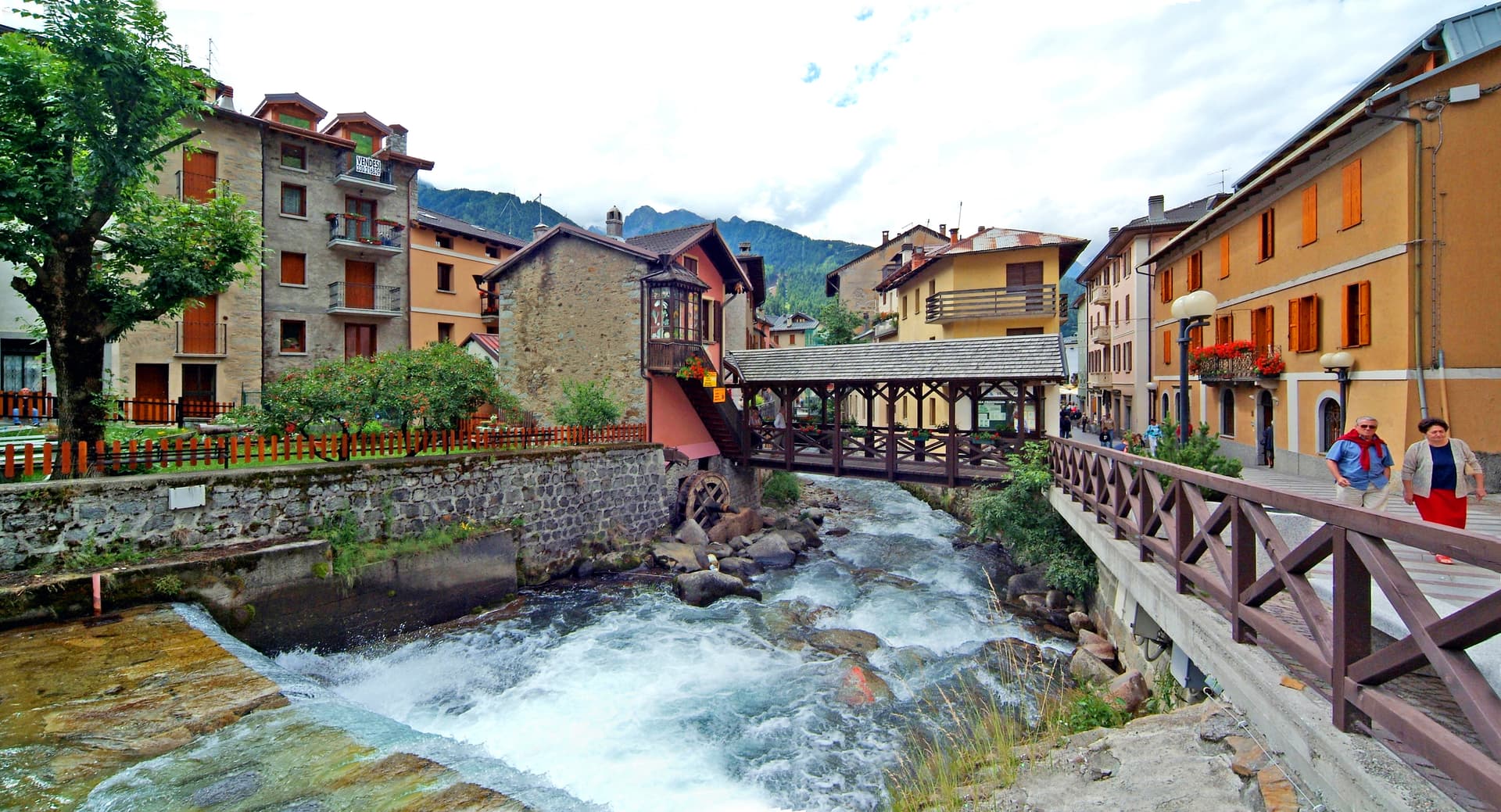
The town's defining feature is older. Nine natural hot springs gush at around 40 degrees from sources at 1,420 meters and feed three thermal centres: QC Terme Bagni Vecchi, QC Terme Bagni Nuovi, and Bormio Terme. The Bagni Vecchi sit above the town in caves and rooms used continuously since the Roman period.
The medieval town center, called the Kuerc, with the ninth-century podestà building, marks the civic heart of the high commune. Bormio remains Italy's southern Alpine ski capital with the Cima Bianca lift system.
The Sunday letter
We haven’t written Bormio’s letter yet.
One town every Sunday, with the photo, the food, the festa. Be there when this one comes up. Free, by Peter & Sophia from Pietrasanta.
By subscribing you agree to Substack’s Terms of Use, our Privacy Policy and our Information collection notice.


What to see
QC Terme Bagni Vecchi
Thermal baths in Roman-era stone rooms and caves above the town, fed by nine springs at 40 degrees, used continuously for two thousand years.
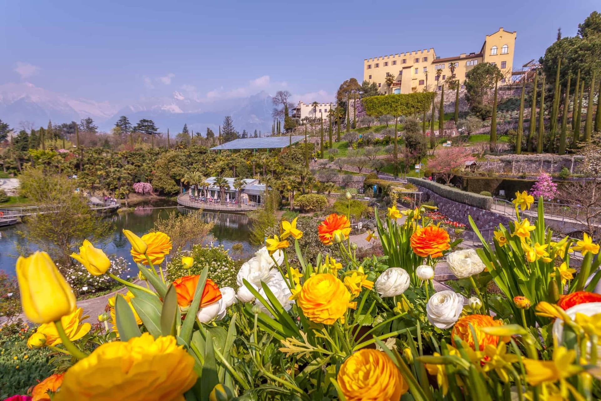
QC Terme Bagni Nuovi
Belle Époque thermal complex below the Bagni Vecchi, with outdoor pools facing the Alpine peaks and the Valtellina valley.
Kuerc e Palazzo del Podestà
Medieval civic center of Bormio, the Kuerc loggia and the ninth-century Podestà building in the heart of the centro storico.
Passo dello Stelvio
2,758-meter Alpine pass, forty-eight hairpins from Bormio, opened in 1825, a regular Giro d'Italia summit finish.
Parco Nazionale dello Stelvio
130,700-hectare national park surrounding Bormio, three-quarters above 2,000 meters, the largest in the central Alps.
Cima Bianca ski area
Bormio's main ski lift system, with the World Cup downhill course Stelvio used for men's racing each December.
The slow-trip planner
Building a trip? Find where Bormio fits in a slow Italy circuit.
Answer five questions. We will shape a geographically coherent slow trip from the 1,000 Italian towns most travelers skip. Yours to save and share.
We recommend
Where to eat and stay
Not our picks, but places the guides put their name to — a Michelin star, a Gambero Rosso fork, a Slow Food snail, a Michelin Key for the hotels. Worth a table, a counter, or a night when you pass through.
Al FilòRistorante
Al Filò holds a Gambero Rosso listing.
GavioliRistorante
Gavioli carries one Gambero Rosso fork (79/100).
Vecchia ComboTrattoria
Vecchia Combo carries two Gambero Rosso prawns.
QC Terme Bagni di Bormio Bagni NuoviHotel
A place in the Michelin hotel guide, at QC Terme Bagni di Bormio Bagni Nuovi.
Living here
- Population 3,960
- Very remotei
- Pharmacy in town
- High school within a 30-minute drive
- Nearest airport Milan, 3 h 0 min drive
- Regional capital Milano, 3 h 32 min drive
Thermal baths in town: Bormio Terme.
Tags & datadesignations · numbers · sources
Recognised as
The numbers
- Elevation: 1225 m
- Population: 3,960
- Surface area: 41.44 km²
These figures were compiled from public directories — ISTAT, OpenStreetMap, Wikidata — and from the official listings of the guides named on this page. Town details change; verify with official sources before you travel.
Close by
More towns near Bormio
Tirano
Province: Sondrio
A Valtellina town at 441 meters where the Bernina railway from St Moritz reaches Italy, beneath terraced Nebbiolo vineyards.
Livigno
Province: Sondrio
At 1,816 meters in the Italian Alps near the Swiss border, a duty-free ski valley that drains north into the Black Sea, not the Mediterranean.
Glurns
Province: Bolzano
The smallest city in South Tyrol at 937 inhabitants, ringed by intact sixteenth-century walls in the Val Venosta near the Swiss border.
Sondrio
Province: Sondrio
The capital of Valtellina at 307 meters, where Castel Masegra watches over terraced vineyards that produce Sassella and Grumello Nebbiolo.
Ponte di Legno
Province: Brescia
The uppermost commune of Valle Camonica at 1,257 meters, where the two source streams of the Oglio meet under the Adamello range.
🌲 Parco Nazionale
More Parco Nazionale towns
Alfedena
Province: L'Aquila
At 914 meters at the head of the upper Sangro valley, the Samnite Aufidena, with a 15,000-tomb necropolis and a Roman conquest in 298 BC.

Barrea
Province: L'Aquila
A 1,066-meter spur above an artificial lake at the heart of the Abruzzo National Park, with a Samnite necropolis and an 11th-century di Sangro castle.

Calascio
Province: L'Aquila
At 1,200 meters under the highest castle in the Apennines, a village of 125 people that played the monk's refuge in Ladyhawke.
Campli
Province: Teramo
A 393-meter town under the Monti della Laga, held by the Farnese for two centuries, with a Scala Santa carrying papal indulgence.

Campo di Giove
Province: L'Aquila
At 1,064 meters under the southwestern Maiella, the highest village in the park, named for a Roman temple to Jupiter.